
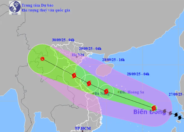
Storm No. 10 Nears Central Vietnam: Rapid Movement, Violent Winds
-
Morning, Sept 28: Storm approaches Da Nang waters, winds level 12–13, gusting to 16.
-
Afternoon, Sept 28: Storm nears the coast from Ha Tinh to Thua Thien Hue, about 160 km off Quang Tri. Land areas from Ninh Binh to Thua Thien Hue begin to experience strong winds and high waves.
-
Morning, Sept 29: The storm makes landfall from Nghe An to northern Quang Tri with winds level 8–9, gusting to 11, before weakening as it moves into Laos.
Disaster risk level: 3.
From the afternoon of September 28, Thanh Hoa to northern Quang Tri will have winds level 6–7, increasing to 8–9; near the storm’s center, winds reach level 10–12, gusting to 14, causing tree falls, power pole damage, and roof loss. Quang Ninh – Ninh Binh and southern Quang Tri – Thua Thien Hue: winds level 6–7, gusting to 8–9. Storm surge of 1.5–2.0m may occur along Thanh Hoa – Nghe An coasts, threatening dikes and coastal roads.
Heavy rainfall is expected from September 28–30. Northern Vietnam and provinces from Thanh Hoa to Thua Thien Hue: 100–300mm, locally over 400mm. Red River Delta and Thanh Hoa – Ha Tinh: 200–400mm, locally exceeding 600mm. High risk of flash floods in small rivers/streams, landslides in mountainous areas, and severe flooding in low-lying regions, especially the northern delta and north-central coast.
Emergency warning: Storm No. 10 is moving rapidly, retaining strong intensity at landfall, with a wide impact zone. Residents from Ninh Binh to Quang Tri must urgently secure homes, evacuate low-lying areas, and safeguard lives and property.
Marine impacts:
-
Northern and central East Sea (including Paracels): winds level 8–9, near center 10–13, gusting to 16; waves 6–10m, extremely rough seas.
-
Coastal waters from Thanh Hoa to Quang Ngai: from evening Sept 27, winds level 6–7, gusting 8–9; by early Sept 28, level 8–9, near center 10–13, gusting to 16; waves 5–7m.
-
Northern Gulf of Tonkin: from early Sept 28, winds strengthening to level 6–7, later 8–9, gusting to 11; waves 3–5m.
-
Storm surge of 1–2m along coasts from Ninh Binh to Ha Tinh, 1.5–2m in Thanh Hoa – Nghe An, with risk of dike overflow, coastal road flooding, and aquaculture damage.
Ý kiến bạn đọc
Những tin mới hơn
Những tin cũ hơn
Luật sư Trần Đình Phúc: Người thầm lặng kiến tạo nên những giá trị bền vững tại Luật Nguyễn
Trong hành trình hơn 25 năm phát triển của Luật Nguyễn, bên cạnh những bước tiến mạnh mẽ và thành tựu đáng tự hào, không thể không nhắc đến những con người đã đặt nền móng và gắn bó trọn vẹn với sự nghiệp chung. Luật sư Trần Đình Phúc là một trong số ấy. 1. Người đồng hành từ những ngày đầu...


-
 Sửa đổi quy định cư trú để phù hợp sắp xếp đơn vị hành chính
-
 Đề xuất đổi căn cước trực tuyến khi thay đổi thông tin do sắp xếp đơn vị hành chính
-
Proposal for Online ID Renewal After Administrative Unit Changes
-
 Legal Action: The Right Path for Businesses Facing Online Defamation
-
Bị bôi nhọ trên mạng, doanh nghiệp nên chọn pháp lý

- Đang truy cập58
- Hôm nay15,273
- Tháng hiện tại563,623
- Tổng lượt truy cập1,332,286
-
 Cập nhật địa chỉ trụ sở Công an cấp xã tại TPHCM sau sáp nhập
-
 Từ ngày 1.7: Cách ghi địa chỉ trên hóa đơn điện tử thay đổi
-
 Địa chỉ 19 Tòa án nhân dân (TAND) khu vực TP.HCM sau sáp nhập
-
 Hóa đơn GTGT xuất cho khách cá nhân có bắt buộc ghi CCCD?
-
Thông tư 40/2021 :Quy định về nghĩa vụ thuế đối với hộ kinh doanh